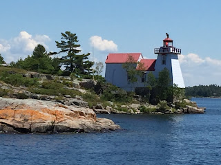
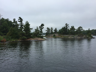
We have now completed Georgian Bay and it's 30,000 islands. We feel a real sense of accomplishment. Although it was beautiful topography - navigation was very stressful, as we passed through numerous channels no wider than the boat and solid granite boulders on both sides. These channels required a "securite" call to alert other boaters as it would be impossible to meet & pass. We followed the "small craft route" - but when it intersected the shipping lanes, buoy color would change - red on left to red on right, Thankfully, the water level on Lake Huron is up - 0.88 meters above chart datum - as our depth in some channels went as low as 5' 8" and we have a 4' 10" draft. We had to go out in the bay to bypass two channels - "Hangdog" and "Canoe" because it was impossible for vessels greater than 40 feet to make the hairpin turns required to stay in the channel.
We had Canadian strip charts and I marked off each bouy, rock marker, etc. as we passed. Several times we had to stop as we were unsure of the route and there was absolutely no room for error! Navigation was like playing a video maze game which required the constant attention of both of us.
Now seeing lots of other boats of all sizes and types. Also seeing lots of stunning, upscale homes built on cliffs overlooking the water. The houses are often estates with guest homes and elaborate boat houses. Appear to be more than summer homes - but not near any towns and often built on islands so not sure what they do in the winter, or how kids get to school, etc. Construction is handled through boats and we see many of them carrying shingles, insulation, etc. which have been loaded off docks from barges.
Saturday July 2 - Beginning of Georgian Bay thru the Collins Inlet -

to Mill Lake, Beaverstone Bay, out into the Bay, and around the Chicken Islands to anchor in the Bustard Islands.
Sunday July 3 - Followed the Northeast Passage thru Dead Island Channel, around Bigsby Island, past the Churchill Islands, and into Rogers Gut,
ending at Britt in the Byng Inlet.
Monday, July 4 Headed down South Channel around Duffy Island then out to sea around the Norgate Rocks and returned via Point Au Baril -
It was 6 miles up the channel to the town. Hundreds of small motor boats were in the channel. The "towns" seem to be composed of 1 store which serves as the marina, grocery, liquor, hardware and sometimes restaurant. We tied to the town dock, but our night was disturbed when a Canadian Coast Guard barge tied up next to us and ran their generator all night.
Tuesday July 5 Middle Channel, Shawanaga Inlet, north of Twin Sisters Island, east thru Shebesherong Channel by Narrows Island to Snug Harbor.
Wednesday, July 6 The small craft route split and we chose to go north to Parry Sound where we stopped for lunch then traveled on through Two Mile Narrows, Three Mile Gap, Five Mile Narrows, and Seven Mile Narrows,
ending in Kineras Bay.
Thursday, July 7 Through Devil's Elbow
down the South Channel to Frying Pan Island, where we stopped for lunch. When we left a fog bank rolled in. We turned on our radar but because we were surrounded by so many islands - and because we were constantly changing directions, it was difficult to pick up other boats. After 2 or 3 boats "popped up" about 50 - 100 feet from us, we decided that navigation, radar, chart plotting and driving - was too much for 2 of us - so we turned back and anchored in a bay.
Two hours later the fog lifted. There was no doubt that we had made the right decision as we then traversed one of the most difficult areas around O'Donnell Point with several S shaped turns to avoid the rocks. That evening we anchored in Indian Harbour.
Friday, July 8 Out to the bay around Galbrath and Splitrock, north of the Valentine Rocks, south of Red Rock through the Muskoka Landing Channel. Through the Main Channel, north of Beausuleil Island. Past Honey Harbour into the Inner Channel and Severn Sound. Last narrow channels were Potato Island Channel and Tug Channel. We - briefly - sighed relief as we had made reservations at a marina in Port Severn and were so glad to have "made it" until we realized that our reserved marina was on the other side of the 1st lock of the Trent Severn Waterway. Lockmaster saw us coming - opened the swing bridge and lock doors while we scrambled to get fenders out and find our lock pass. This is the smallest lock - and hand operated! Marina is also a resort & spa - so - in addition to our usual re-provisioning, cleaning, laundry, etc, - we took time to enjoy the pool.
Now - on to the other 44 locks on the Trent Severn Waterway.


It sounds like this whole "retirement boating" thing is more difficult than my job! I should have made you both play more video games for practice. I'm glad you chose to wait out the fog--sounds like a good decision. The pics are great! We like the Indian Harbour one.
ReplyDelete